|
Bird's-Eye View - c.1460 (Drawn by FC Mears, 1919) |
© For permission to reproduce, please contact peter.stubbs@edinphoto.org.uk
|
Bird's-Eye View of Edinburgh c.1460 |
|
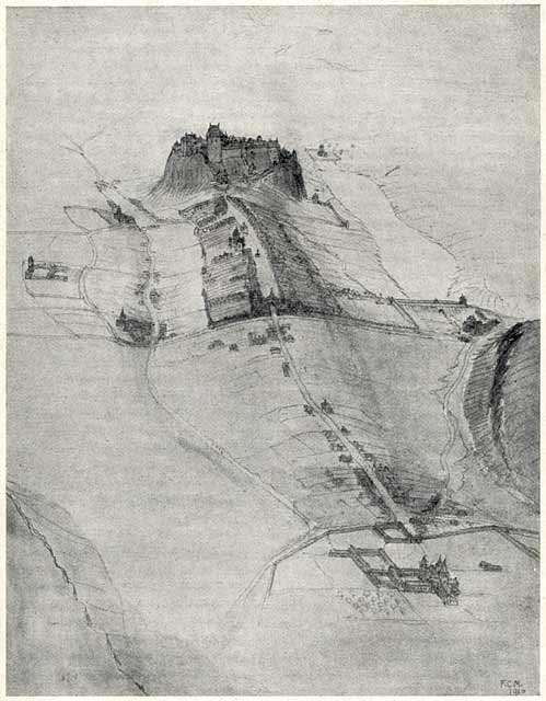
Here is a bird's eye view of Edinburgh, looking west towards Edinburgh Castle from a point above St Margaret's Loch in Holyrood Park. The ridge running down from Edinburgh Castle can clearly be seen, first within the town walls to the Nether Bow Port, then across open land to the borough of the Canongate and Holyrood Palace. The road on the crest of the hill is now the Royal Mile. The road road running parallel, in the valley to the left is the Cowgate. At the time that depicted in this drawing, the Cowgate was entirely outside the walls of Edinburgh. The Nor' Loch is in the upper-right corner of the picture, in the valley to the north of the castle. The lower slopes of Calton Hill can be seen at the extreme-right of the picture, and the lower slopes of the hill in Holyrood Park, beneath Salisbury Crags can be seen in the lower-left corner of the picture. |
|
The Birds-eye View above is taken from an article titled 'Primitive Edinburgh' by FC Mears, Captain RAF, Architect, published in Scottish Geographical Magazine Vol XXXV (1919), pp.298-315. It was reproduced in 'The Early Views and Maps of Edinburgh 1544-1852', published by the Royal Scottish Geographical Society, Edinburgh in 1919. |
|
MAPS: Full index |
|
MAPS: Short Index with thumbnails |