My Photographs1990s and 2000s |
|
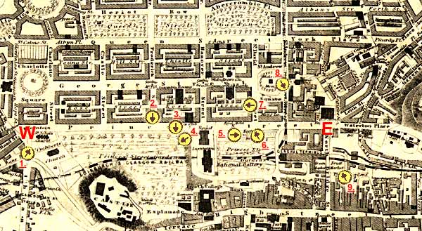
This page displays a map of central Edinburgh. Princes Street runs through the centre of this map. The West End and East End of Princes Street will be marked W and E. The yellow circles will show where several of my photos were taken from in the 1990s and early 2000s. The arrows within the circles will show the direction that I was facing. Please click on the arrows to see the photographs. This map may be slow to load, so please wait until it appears. Thank you. |
Please
click on one of the arrows below
A key to the
numbers appears below the map.
Around Edinburgh
© Copyright: Peter Stubbs - please contact peter.stubbs@edinphoto.org.uk
|
KEY TO MAP |
||||||||
|
Running across the centre of the map below is Princes Street from the West End W ... to the East End E These views can be seen by clicking on the arrows in the map below: 1. = St John's Church at the West End of Princes Street (from Lothian Road) 2. = Royal Scots Greys Statue in Princes Street Gardens (from Frederick St.) 3. = Ramay Garden (looking from Princes Street - summer view) 4. = Edinburgh Castle (looking from Princes Street Gardens - evening view) 5. = The Big Wheel and Scots Monument (Princes Street - Christmas Season) 6. = Jenners' Department Store (from the Scott Monument - Christmas Eve) 7. = Rose Street behind Jenners' Department Store (late afternoon shadows) 8. = Royal Bank of Scotland in St Andrews' Square (looking up at statues) 9. = The North Bridge and Balmoral Hotel (looking up from Market St. - floodlit)
|
|
NOTES on the MAP |
|
|
The map used above is:
I have used this 1860 map on several pages in this web site, to show links to photographs from many different periods, 1850s 1950s 2000. Remarkably little has changed in the area covered by this map, except for the demolition of St James Square and its replacement by buildings for the Scottish Office, a hotel and the St James Shopping Centre. This area is immediately to the East of the arrow numbered 8 on the map. |
|
NOTES on the PHOTOGRAPHS |
|
The photographs linked to this map are described as having been taken around 2000. This is an approximate date. They have, in fact been taken from the early 1990s to date. |
|
MAPS: Full index |
|
MAPS: Short Index with thumbnails |