My Photographs1990s and 2000s |
|
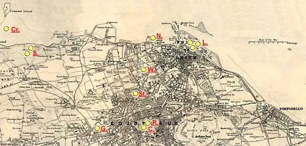
This page displays a map covering the area from Cramond Island in the west to Portobello in the east. Edinburgh, Leith and Newhaven are close to the centre of the map. At the top of the map is part of the Firth of Forth. The yellow circles will show where several of my photos were taken from in the 1990s and early 2000s. The arrows within the circles will show the direction that I was facing. Please click on the arrows to see the photographs. This map may be slow to load, so please wait until it appears. Thank you. |
Please
click on one of the arrows below
A key to the
numbers appears below the map.
Around Edinburgh
© Copyright: Peter Stubbs - please contact peter.stubbs@edinphoto.org.uk
|
KEY TO MAP |
||||||||
|
These views can be seen by clicking on the arrows in the map below: C. = Edinburgh Cramond (from the Grassmarket - Firework Display)) Cr. = Cramond (looking towards Cramond Breakwater from Silverknowes)) G. = Gorgie (The North British Distillery - Cooperage Yard) L. = Leith Docks (1.The Ark Royal; 2. Old dock cranes; 3. Ship in Dry Dock) N. = Newhaven Fishmarket (the old fishmarket, before the Museum opened)) R. = Ramsay Gardens (beside Edinburgh Castle - from Princes Street - winter) S. = Silverknowes (1. golf course; 2. trees beside the Firth of Forth - winter) St. = St Stephen's Church (inside the church tower - Stockbridge, Edinburgh) W. = Warriston Cemetery (old gravestones and bluebells)
|
|
NOTES on the MAP |
|
|
The map used above is:
I have used this 1860 map on several pages in this web site, to show links to photographs from many different periods, 1850s 1950s 2000. Remarkably little has changed in the area covered by this map, except for the demolition of St James Square and its replacement by buildings for the Scottish Office, a hotel and the St James Shopping Centre. This area is immediately to the East of the arrow numbered 8 on the map. |
|
NOTES on the PHOTOGRAPHS |
|
The photographs linked to this map are described as having been taken around 2000. This is an approximate date. They have, in fact been taken from the early 1990s to date. |
|
MAPS: Full index |
|
MAPS: Short Index with thumbnails |