|
Photographs of Central Edinburgh from the Evening News Collection 1950s |
© Copyright: Peter Stubbs - please contact peter.stubbs@edinphoto.org.uk
|
Map and Key to Photos |
|
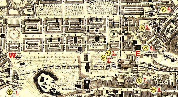
Princes Street runs through the centre of the map above. - W = West End of Princes Street - E = East End of Princes Street The yellow circles show where photos were taken from, and the direction the camera was pointing. Please click on these arrows to see the photos. 1. = Lothian Road (looking towards the West End) 2. = Princes Street Gardens (looking towards Edinburgh Castle) 3. = Trams in Princes Street (looking from the Scott Monument) 4. = Aerial View (looking over St James Square towards the GPO) 5. = St James Square (view from the ground looking towards the GPO) 6. = Looking down Leith Street (from the East End of Princes Street) 7. = North Bridge (looking towards Princes Street and the North British Hotel) 8. = The High Street (looking up towards the Tron Kirk and St Giles Cathedral) |
|
Maps for Begbie photos |
|
|
Maps for photos: |
|
|
Maps for engravings: |
|
|
Photographs |
Around Edinburgh |
|
MAPS: Full index |
|
MAPS: Short Index with thumbnails |
|
Full Index |
|
Princes Street views: from Calton Hill Preparing for the Trams Princes Street Gardens |
|
Other street views: |