History of Edinburgh Please scroll down to read the whole page, or select a paragraph below ... |
|
Early History |
|
There is some uncertainty about the early history of Edinburgh, many of the records having been lost in early invasions. However, Edinburgh is believed to have taken its name from Edwin of Deira who fortified the castle rock around 617AD. Edinburgh has a long history, that pre-dates photography by many centuries. Yet, some of the buildings painted by the 17th and 18th century artists and photographed by the mid-19th century photographers can still be recognised today. Edinburgh was originally a walled town, extending less than a mile down the ridge to the east from Edinburgh Castle. As recently as 1763, the area of Edinburgh was only about 1 square mile. Its boundaries expanded gradually, and by 1840, when photography came to Edinburgh, the area covered was about 4 square miles. The City's expansion, with the creation of the New Town, was well underway. The population of Edinburgh has gradually grown. It was about 100,000 in 1811, 160,000 in 1841 and 270,000 in 1891, and is about half a million today. |
|
Edinburgh Old Town |
|
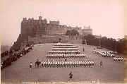
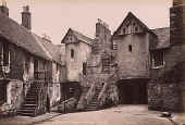
Edinburgh Castle to Holyrood Palace Edinburgh Old Town is built on a ridge extending for about a mile down the slope to the east from Edinburgh Castle (with its buildings dating from the 12th century onwards) towards Holyrood Palace and Abbey. The Great Hall of Edinburgh Castle dates from the early 16th Century. Its timber roof was much restored by the architect, and Edinburgh Photographic Society President, HJ Blanc in 1888. [IAG] The One 'o Clock Gun is a cannon that, for over 140 years, has been fired from Edinburgh Castle to signal the time of day. |
|
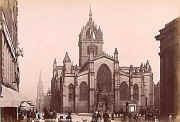
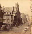
The High Street The houses in the Old Town were built high and close together, with narrow alleys, or closes, between. Landmarks on the Royal Mile, that leads from Edinburgh Castle include St Giles' Cathedral, John Knox's House, and White Horse Close. |
|
Edinburgh New Town |
||
|
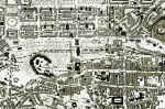
James Craig's Plan 1766 Edinburgh's New Town was built to enable Edinburgh's inhabitants to live in more spacious surroundings, away from the unhygienic high-rise buildings of the Old Town. The New Town consists of a formal arrangement of straight streets, squares and crescents, based on plan designed by James Craig in 1766. The New Town occupies the top half of this map of 1860, with Princes Street running from West to East along the centre of the map. It can be contrasted with the narrow streets and closes of the Old Town in the bottom right hand corner of the map. [Please click on this map, or on any other small images to see enlargements.]
|
||
|
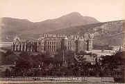
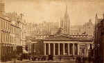
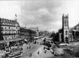
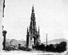
Princes Street Princes Street was the location chosen by most of Edinburgh's early photographers. For most of the length of Princes Street, there were buildings only on the northh side. The top floors of these buildings would have been bright and have had an open outlook towards Edinburgh Castle. Princes Street extended from St John's church at the West End, past the National Galleries and the Walter Scott Monument towards the site where the North British Hotel, now the Balmoral Hotel, stands at the East End.
|
||
|
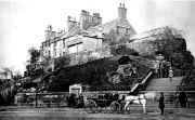
Rock House About a quarter of a mile beyond Princes Street, to the east, lies Rock House, where Hill & Adamson's studio was based, 1843-47, at the foot of Calton Hill |
|
Dates |
|
Please click here to see a list of dates when - foundation stones were laid - buildings were opened - buildings were destroyed by fire - royalty visited Edinburgh - streets were lit - canals, railways and tramways were built - etc. |
|
Edinburgh |