|
Edinburgh New Town
East End |
|
|
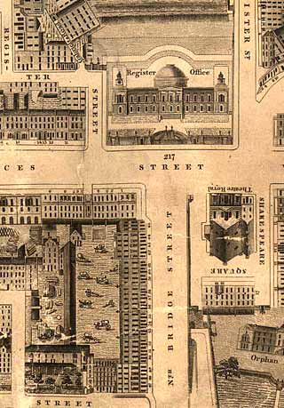
Kirkwood Map - 1819
©
Reproduced
by courtesy of the National Library of Scotland. |
Aerial View - 2001
©
Copyright: XYZ Digital Map Company Limited. |
|
|
|

|
East End |
|
|
Little now remains of the buildings in this part of Kirkwood's map of 1819. Register House was completed in 1783 and is still standing, looking very similar to the picture above, but with Steele's statue of the Duke of Wellington on his horse in front of the building. The buildings on the left at the end of North Bridge, at its junction with Prices Street, with their yard of coaches in the centre were demolished and replaced by the North British Railway Hotel (now the Balmoral Hotel) around a century ago. Shakespeare Square with its Theatre Royal were demolished and the foundation stone laid for the General Post Office in 1861, the year that Edinburgh Photographic Society was founded. The Post Office moved out of the GPO in the 1990s. The building is now a shell with only the exterior walls still standing, but with new offices being constructed inside. The Orphan's Hospital (Trinity Hospital) in Low Calton, in the lower-right corner of this map was demolished to make room for Waverley Station and the railway. |
|
|
Kirkwood Map - 1819 |