Engraving from Old & New Edinburgh - published 1890 High Street Wynd |
|
© For permission to reproduce, please contact peter.stubbs@edinphoto.org.uk |

|
High Street Wynd |
|
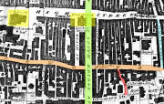
On the map below (which can be enlarged by clicking on it), High Street Wynd is in the lower right-hand corner of the map, coloured red. It is an extension of Infirmary Street. This route leads to the east from South Bridge, then turns the corner and down the hill past the end of High School Yards, then down the hill to Cowgate. Lady Yester's Church was originally situated in High School Wynd. It was demolished in 1803 and rebuilt on a site further to the west the following year. The church does not appear in the engraving of High Street Wynd above (after Ewbank). |
|
Engravings Thumbnail images |
||