|
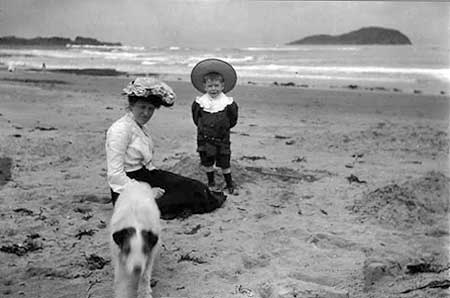
Near Edinburgh? On the Beach |
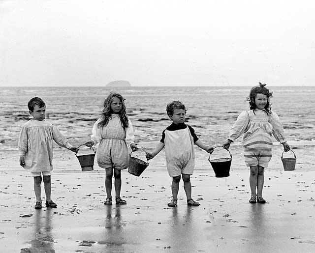
© Reproduced with acknowledgement to John Stirling, Currie, Edinburgh: November 6, 2009 Photographer not known
|
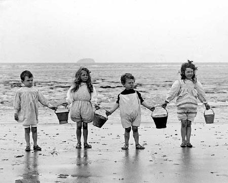
On the Beach |
|
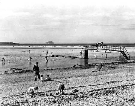
Old Photo Thank you to John Stirling for allowing me to reproduce this photo. The photo is taken from a collection of lantern slides that John rescued from being destroyed in 1974. The photographer is not known. Some of the other slides from this series are known to have been taken between about 1910 and 1920. |
|
When and Where? Is it near North Berwick? If you can suggest when and where this photo might have been taken, please email me. Maybe the photo was taken from North Berwick in East Lothian (about 25 miles to the east of Edinburgh) or nearby, with the Bass Rock in the background. The top of the rock looks a little flatter than it appears on some photos, but it, no doubt, looks different when photographed from different positions. Peter Stubbs: November 22, 2009 |
|
Recollections Replies |
||
|
1. |
Walter Lyle Hume |
Craigleith from North Berwick |
|
2. |
David Bain |
Bass Rock from Aberlady |
|
3. |
Bryan Gourlay |
Craigleith from North Berwick |
|
4. |
Walter Lyle Hume |
The Lamb from North Berwick |
|
5. |
Archie Foley |
NOT Craigleith |
|
6. |
David Bain |
Bass Rock from North Berwick |
|
7. |
Bryan Gourlay |
Bass Rock from North Berwick |
|
8. |
Bob Henderson |
Bass Rock from Tantallon Castle |
|
9. |
Bryan Gourlay |
The Lamb from North Berwick |
|
10. |
David Bain |
Bass Rock from East of Tantallon |
|
11. |
David Bain |
Bass Rock from Bellhaven? |
|
12. |
Bill
Fulton |
Bass Rock from Bellhaven? |
|
13. |
David Anderson |
Ailsa Craig from Ayr Sands |
|
14. |
Ian Stewart |
Ailsa Craig |
|
15. |
David Anderson |
Ailsa Craig from Ayr Beach |
|
16. |
David Bain |
NOT Ailsa Craig |
|
17. |
Winnie Lisowski |
Bass Rock from Bellhaven |
|
18. |
Winnie Lisowski |
Steep Holm from Weston-super-Mare |
|
19. |
David Bain |
Steep Holm from Weston-super-Mare |
|
20. |
Winnie Lisowski |
NOT Bass Rock |
|
21. |
Roger McDermaid |
Ailsa Craig from Maidens |
|
22. |
Roger McDermaid |
Ailsa Craig? |
|
23. |
Bass Rock from the Fife Coast |
|
|
24. |
Donald Grant |
Steep Holm in the Bristol Channel |
|
Answer 1. Walter Lyle Hume Cowes, Isle of Wight, England |
|
Thank you to Walter Lyle Hume who wrote: |
|
"Here is another photo taken on the beach, circa 1925. This photo has Craigleith Island in the background. Food for thought!" Craigleith Island © Reproduced with acknowledgement to Walter Lyle Hume ,Cowes, Isle of Wight, England Walter Lyle Hume, Cowes, Isle of Wight, England: November 23, 2009 |
|
Craigleith Island Craigleith Island is in the Firth of Forth, about a mile to the north of North Berwick and 3 miles to the west of the Bass Rock. The island in the photograph at the top of this page appears to have less of a slope than Craigleith in the photograph above. However, maybe the shape of Craigleith looks different when viewed from different parts of the coast near North Berwick. Peter Stubbs: November 23, 2009 |
|
Answer 2. David Bain Rotherham, South Yorkshire, England |
|
Thank you to David Bain who wrote: |
|
East Lothian "Aberlady? I'm sure that's the Bass Rock in the background." David Bain, Rotherham, South Yorkshire, England: November 23, 2009 |
|
Aberlady? If the island is the Bass Rock, or even if it's Craigleith Island, I don't think the photo could have been taken from Aberlady, because there is no clear view across the water to of either of these islands from Aberlady. The headland to the west of North Berwick is in the way. Peter Stubbs: November 23, 2009 |
|
Answer 3. Bryan Gourlay Biggar, Lanarkshire, Scotland |
|
Thank you to Bryan Gourlay for sending me two photos, showing the shape of Craigleith Island as seen from North Berwick. Bryan took these photos at Easter 2009. Here is one of them: Craigleith Island © Bryan Gourlay, Biggar Lanarkshire, Scotland Photo taken Easter 2009
|
|
Bryan wrote: Not Craigleith "The island in the photo of the four children is a different shape and looks to be too far offshore to be Craigleith. It's also not the same shape as the Bass Rock looking from North Berwick. Perhaps it has been taken further East of the town from a beach near Seacliffe close to Tantallon Castle, where it would also be a little bit further offshore" Bryan Gourlay, Biggar, Lanarkshire, Scotland: November 24, 2009 |
|
Answer 4. Walter Lyle Hume Cowes, Isle of Wight, England |
|
Thank you to Walter Lyle Hume who wrote: |
|
"Having been brought up in North Berwick, albeit many years ago, I got to know the offshore Islands very well, to say nothing of my years the Northern Lighthouse ships. This picture could even be the Lamb, between the Craig and Fidra. I am sure it is not the Bass. Walter Lyle Hume, Cowes, Isle of Wight, England: November 24, 2009 |
|
The Lamb is: - about 1 mile NW of North Berwick and - about 1 mile WSW of Craigleith. Peter Stubbs: November 24, 2009 |
|
Answer 5. Archie Foley Joppa, Edinburgh |
|
Thank you to Archie Foley for sending me a photograph of the Bass Rock, taken from a passing ferry, and for also sending this photo with Craigleith in the background. |
|
Archie wrote: "I have looked through my collection of North Berwick images made from restored negatives from about 1905. I can't find one with the Bass Rock in the background. However, this one of Nurse Annie and Tommy with dog shows the distinctive shape of Craigleith. Craigleith Island
© Reproduced with acknowledgement to Archie Foley Photo taken around 1905 Archie Foley, Joppa, Edinburgh: November 24, 2009 |
|
Answer 6. David Bain Rotherham, South Yorkshire, England |
|
Thank you to David Bain for telling me me about more photos of the Bass Rock and Craigleith that appear elsewhere on the internet. Following on from his comments in 'Answer 2' above, David added: |
|
East Lothian "I just had to keep digging (sand) on this one. I was wrong about Aberlady - I haven't been there for thirty-odd years! But I think I was right about the Bass. If so, the photo looks to me to have been taken from somewhere to the east of North Berwick." David Bain, Rotherham, South Yorkshire, England: November 25, 2009 |
|
Answer 7. Bryan Gourlay Biggar, Lanarkshire, Scotland |
|
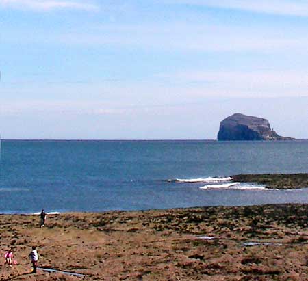
Thank you to Bryan Gourlay for sending me this photo showing the shape of the Bass Rock, seen from outside the Seabird Centre at North Berwick.
The Bass Rock © Bryan Gourlay, Biggar Lanarkshire, Scotland Photo taken Easter 2009 Acknowledgement: Bryan Gourlay, Biggar, Lanarkshire, Scotland: November 24+25, 2009 |
|
Answer 8. Bob Henderson Burdiehouse, Edinburgh |
|
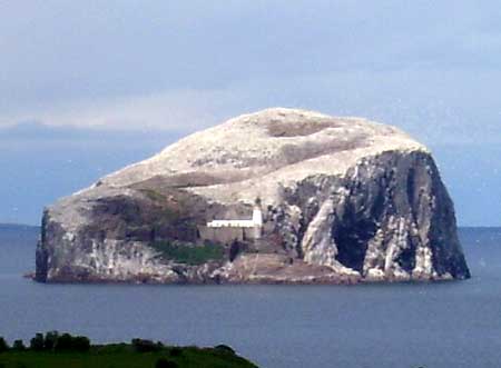
Thank you to Bob Henderson for sending me two more photos of the Bass rock. Both are views looking to the Bass Rock from Tantallon Castle. Here is one of them:
The Bass Rock © Bob Henderson, Burdiehouse, Edinburgh Acknowledgement: Bob Henderson, Burdiehouse Edinburgh 25, 2009 |
|
Comparison with the Mystery Photo Neither the photo above nor that in 'Answer 7' above shows the Bass Rock as being a good match for the island in the background of the old photo above, but I feel we're getting closer. The island in the old photo looks lower than the Bass Rock, but perhaps the old photo was taken at high tide and the two recent photos at low tide - or alternatively, perhaps the island in the old photo is not the Bass Rock!
© Reproduced with acknowledgement to John Stirling, Currie, Edinburgh: November 6, 2009 Peter Stubbs, Edinburgh: November 26, 2009 |
|
Answer 9. Bryan Gourlay Biggar, Lanarkshire, Scotland |
|
Thank you to Bryan Gourlay for emailing me again, enclosing this photo of the Lamb, an island about a mile NW of North Berwick. The photo was taken from North Berwick at Easter 2009. Bryan wrote: The Lamb "I am not as well versed in the islands around North Berwick as Walter Lyle Hume (Answer 4 above) – but here is a photo I took this year of what I think is the Lamb in the distance. It's about a mile to the left of Craigleith, just where you describe it. It looks about the right shape for the island behind the girls on the beach.
The Lamb © Bryan Gourlay, Biggar Lanarkshire, Scotland Photo taken Easter 2009 Acknowledgement: Bryan Gourlay, Biggar, Lanarkshire, Scotland: November 25, 2009 |
|
Answer 10. David Bain Rotherham, South Yorkshire, England |
|
Thank you to David Bain for writing again, telling me about his further investigations. David wrote: |
|
The Bass Rock "I have now searched all the available photographs and have worked out, by the visible shape of the Bass and its relative size in the photograph, that the scene of four children on the beach would have been taken from further East than Tantallon and further North than Dunbar." After another look at the map, my money would be on the photo having been taken at Belhaven." David Bain, Rotherham, South Yorkshire, England: November 27, 2009 |
|
David: Trying to match the shape of the Bass rock, when viewed from different angles is important, care should be taken in drawing any conclusions from the size of the bass rock in the photo, when it is not known what lens camera and lens was used to take the photo, and whether or not the photo has been cropped. e.g. If two photos were taken on the beach: - one with a 50mm lens and the children 10 yards away - one with a 100mm (i.e. more telephoto) lens and children 20 yards away The children would look the same size in each photo, but the length and height of the Bass Rock would appear to be double in the second photo. Peter Stubbs, Edinburgh: November 28, 2009 |
|
Answer 11. David Bain Rotherham, South Yorkshire, England |
|
David Bain followed up with this message: |
|
The Bass Rock "I am now more confident than ever that the photo was taken at Belhaven, with the Bass Rock in the background. The Lamb is a good shape, but the Bass is a better match." David Bain, Rotherham, South Yorkshire, England: November 27+28, 2009 |
|
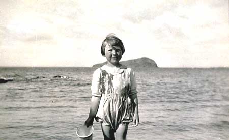
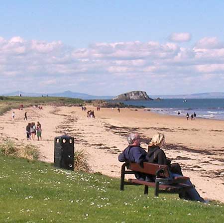
David based this conclusion on a photo of children playing at Belhaven, Sands, Dunbar, with the Bass Rock in the background. The photo is from a negative by Valentines, registered October 19, 1955. It is reproduced below. A half-plate print of this photo is held in the St Andrew's University Library. The 1955 photo and early 'mystery photo' are compared below. Belhaven Bay seems a likely place for children to have been photographed, beside the sea, in the early photo, but was that photo actually taken there? The shape of the Bass Rock looks similar, but not identical, in both photos below. 1955
©
Reproduced courtesy
of the University of St Andrew's Library. Project763, Ref
JV-D1146
Early 1900s © Reproduced with acknowledgement to John Stirling, Currie, Edinburgh: November 6, 2009 Peter Stubbs, Edinburgh: December 2, 2009 |
|
Answer 12 Bill Fulton East Lothian, Scotland |
|
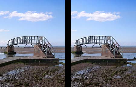
Thank you to Bil Fulton, a keen stereo photographer living in East Lothian, Scotland, for recognising this view of the bridge at Belhaven, Dunbar and sending me one of his photos taken at the same location in 2010. Bil wrote: |
|
Belhaven "This structure at Belhaven is known as 'The Bridge to Nowhere'. There is a good view of the Bass Rock in the background from here. This is one of our favourite spots when we are walking or cycling. 2010 © Bil Fulton, East Lothian, Scotland. Photo taken 2010 This is a stereo shot that I took of the bridge in 2010, using a single camera." Bil Fulton, East Lothian, Scotland: April 26+28, 2011 |
|
Answer 13. David Anderson Glasgow, Scotland |
|
David Anderson wrote: |
|
Further Afield? "I'm wondering if the net may have to be cast further afield. Can I throw Ailsa Craig into the equation? I'm wondering about whether the image might be reversed, combined with the light direction and the profile of the island - perhaps Ayr Sands." David Anderson, Glasgow, Scotland: January 21, 2012 |
|
David: Most of the other photos in the collection that this one came from were taken in or near Edinburgh. From all the evidence and comments to date, it seems likely to me that this photo would have been taken on the Forth, probably at Belhaven Bay near Dunbar in East Lothian. See Reply 11 above. I'll leave others to comment further. Peter Stubbs, Edinburgh: January 21, 2011 |
|
Answer 14. Ian Stewart Morningside, Edinburgh |
|
Ian Stewart wrote: |
|
Ailsa Craig "It could be Ailsa Craig." Ian Stewart, Morningside, Edinburgh: January 22, 2012 |
|
Answer 15. David Anderson Glasgow, Scotland |
|
David tells me that he lives in Glasgow and works in Dunbar, East Lothian, so he is familiar both with beaches on the west coast of Scotland and on the Firth of Forth in East Lothian. David wrote: |
|
Ailsa Craig? "When I saw this photo, the shape, position and orientation of the beach and rock did not immediately strike me as being one of the beaches that I was familiar with on the East Lothian coast of the Firth of Forth. Having wandered through Google images, I tend to the view that it is a reversed image of Ailsa Craig from Ayr beach. We take our wee laddie to Ayr. Hence my observation." David Anderson, Glasgow, Scotland: January 23 2012 |
|
Answer 16. David Bain Rotherham, South Yorkshire, England |
|
Thank you to David Bain who wrote: |
|
Not Ailsa Craig? "I've looked at any available photographs of Ailsa Craig and it looks too 'pointy' to me. We desperately need a volunteer to take a Sunday run out to prove or disprove the Bass by taking photographs near the tide line at Belhaven. I'd do it but I'm 250 miles away! The matching focal length is moot but a set of images through the range of a standard zoom should achieve something like the original field of view." David Bain, Rotherham, South Yorkshire, England: January 25, 2012 |
|
Answer 17. Winnie Lisowski Dunbar, East Lothian, Scotland |
|
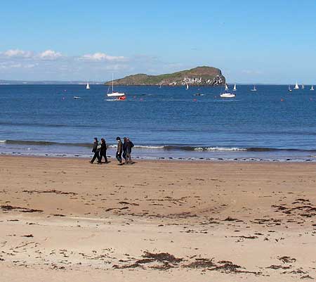
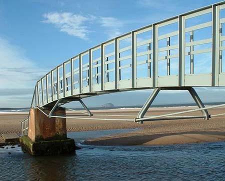
Thank you to Winnie Lisowski for also sending me three photos of the beach and bridge at Bellhaven near Dunbar, with the Bass rock in the background, all taken in 2002. I've reproduced one of Winnie's photos below, followed by the 'Early 1900s' photo for comparison. |
|
2002 © Winnie Lisowski, Dunbar, East Lothian, Scotland, Feb 11, 2012. Photo taken 2002 Early 1900s © Reproduced with acknowledgement to John Stirling, Currie, Edinburgh: November 6, 2009
|
|
Acknowledgement: Winnie Lisowski, Dunbar, East Lothian, Scotland: February 11, 2012 |
|
Answer 18. Winnie Lisowski Dunbar, East Lothian, Scotland |
|
Thank you to Winnie Lisowski for writing with another suggestion about where this photo might have been taken: © Reproduced with acknowledgement to John Stirling, Currie, Edinburgh: November 6, 2009 Winnie wrote: |
|
Mystery Rock "We have just watched 'Inside Men' on BBC which we taped during the week and there was a scene in it at a beach, my husband immediately said: "That is the 'mystery rock'." I immediately had to agree as it jumped out at being the right one, don't know why it just looked right in every way. We couldn't believe it. Unfortunately, they didn't say where it was - somewhere in England, I would think." Winnie Lisowski, Dunbar, East Lothian, Scotland: February 17, 2012 |
|
Winnie wrote again, after doing a little more investigation. |
|
Steep Holm Weston-Super-Mare "I went to the message board on BBC, asking anyone if they knew where this beach that was featured on Inside Men could be. I have had 3 replies already, saying its Weston-Super-Mare beach and the rock is Steep Holm. We have checked the google map and Steep Holme's profile viewed from Weston-Super-Mare certainly matches with the 1900 photo. Let me know your thoughts on this." Winnie Lisowski, Dunbar, East Lothian, Scotland: February 18, 2012 |
|
Reply Here are links to the Google Images pages for: - Steep Holm, Weston-super-Mare, Somerset and - Bass Rock, Dunbar, East Lothian The shapes of both these islands in the Google Image photos varies according to the viewpoint and, no doubt, the state of the tide. I must agree that some of the Steep Holm photos seem to give the best match for the shape of the rock in the photo taken around 1900. However the photo taken around 1900 comes from a set in which I believe all the other photos were taken in or around Edinburgh, so how likely is it that one of the photos was taken at Weston-super-Mare? Peter Stubbs: Edinburgh: February 18, 2012 |
|
Answer 19. David Bain Rotherham, South Yorkshire, England |
|
Thank you to David Bain who wrote again: |
|
Steep Holm "Despite having been a keen proponent for The Bass, I had spent an hour earlier this week looking at other possibilities because I came to the conclusion that The Bass has a slightly more pointed profile than the rock in the picture. I had looked at The Cumbraes but they're too flat, Ailsa Craig is too pointy, but Steep Holm looks like the best bet yet. As to continuity, there might have been months between exposures if the photographer was a 'high days and holidays only' type." ** David Bain, Rotherham, South Yorkshire, England: February 19, 2012 |
|
** David Your 'high days and holidays' explanation sounds plausible, except for the fact that the other photos in this collection are not family shots. They are a collection of lantern slides that appear to have been taken for Edinburgh Corporation Health Dept, some apparently promoting the benefits of sports and outdoor activities. These lantern slides were 'rescued' and narrowly escaped being thrown out. Unfortunately, I don't know of any papers that have survived relating to this collection, and the individual lantern slides are not captioned. Peter Stubbs, Edinburgh: February 19, 2012 |
|
Answer 20. Winnie Lisowski Dunbar, East Lothian, Scotland |
|
Thank you to Winnie Lisowski for writing again. Winnie wrote: |
|
NOT The Bass Rock "I was looking at the Bass Rock photos in the link given in the Reply to Answer 18 above. The Bass Rock has a 60 degree angle on the right side and 45degree on the left side which rules it out." Winnie Lisowski, Dunbar, East Lothian, Scotland: February 17, 2012 |
|
The Bass Rock? I've also been looking at the photos in that link. I agree. The shape of the Bass Rock does not seem to be a good match for the island in the old photo. The shape of the Bass Rock seems to vary from photo to photo, but in none of them does the top look flat enough to match the island in the old photo. Peter Stubbs, Edinburgh: February 19, 2012 |
|
Answer 21. Roger McDermaid Corstorphine, Edinburgh |
|
Thank you to Roger McDermaid who wrote: |
|
Ailsa Craig "I'm pretty sure that this photo is of Ailsa Craig." Roger McDermaid, Corstorphine, Edinburgh: February 21, 2012 (1st email) |
|
Roger wrote again, adding |
|
Ailsa Craig "I've looked up map, and I'm quite prepared to wager that this photo was taken at a place that I've driven through, when at Turnberry. It's a sort of typical wee seaside spot with caravans - a sort of of west coast Port Seton. My cash`s on that " Roger McDermaid, Corstorphine, Edinburgh: February 21, 2012 (2nd email) |
|
I've also been looking at the photos in that link. I agree. The shape of the Bass Rock does not seem to be a good match for the island in the old photo. The shape of the Bass Rock seems to vary from photo to photo, but in none of them does the top look flat enough to match the island in the old photo. Peter Stubbs, Edinburgh: February 19, 2012 |
|
Answer 22. Roger McDermaid Corstorphine, Edinburgh |
|
Thank you to Roger McDermaid who wrote: |
|
Ailsa Craig? "My wife thinks this photo is of the Bass Rock, taken from Dunbar. But I agree with 13 above, and now think that the photo is of the Craig, taken from either Ayr or Maidens because of the shape of the rock, and I think that if it was the Bass Rock, it would appear to be bit nearer." Roger McDermaid, Corstorphine, Edinburgh: March 8, 2012 (2 emails) |
|
Hi Roger: The shape of the rock should be a good guide to which rock it is, thought the shape of the Bass Rock does seem to vary a lot depending on the viewpoint and the state of the tide. I recommend not trying to draw conclusions from how close the rock seems to be. Use of a wider focal length lens is likely to make the rock look smaller and further away; use of a telephoto lens will make it larger (compared to the size of the children) and closer. Peter Stubbs, Edinburgh: March 8, 2012 |
|
Answer 23. Milton Hey |
|
Thank you to Milton Hey for making another suggestion. Milton wrote: |
|
The Bass Rock "I've just come across your query about the photograph of the four children on the beach, after Bing featured the footbridge onto Belhaven beach. I believe that this photo is of the Bass Rock, taken from the Fife coast." Roger McDermaid, Corstorphine, Edinburgh: June 14, 2013 |
|
Hi Milton: Photo from the Fife Coast Thanks for your suggestion above. It's just over a year since anybody sent me a response to this photo, so we'll see if the subject comes to life again now. You are the first person to have suggested that the photo might have been taken from the Fife coast. Can you tell me why you make that suggestion? Is it the outline shape of the rock? Peter Stubbs, Edinburgh: June 16, 2013 |
|
Answer 24. Donald Grant Penicuik, Midlothian, Scotland |
|
It's almost a year since anybody sent me a message speculating on where this photo might have been taken, but I've now received another reply. It comes from Donald Grant who wrote: |
|
Steep Holm "I've been killing time this morning due to the wet weather and had a look through some of your mystery photos, in particular the photo that appears to be the Bass Rock. Reading through some of the comments, I noted that Steep Holm, an island in the Bristol Channel was suggested. Not being familiar with the area I went looking via Google to find out more. I came across this image on the web. Having studied both this image and the one on your site I'm in no doubt that they are both of the same island. The profile of the island is virtually identical in both images, and knowing that Steep Holm is five miles offshore (much farther than the Bass Rock) I would say that the perspective is correct in your image. *** Not the Bass Rock or Ailsa Craig As some have suggested the profile of the Bass Rock is too 'pointy' to be the island in your photo and to my mind Steep Holm is a far more likely candidate. Ailsa Craig can also be discounted as its profile does not match your image or the one I've highlighted. Donald Grant, Penicuik, Midlothian Scotland |
|
Comment *** Hi Donald: Thanks for your research and observations. I found the link that you sent to be interesting. - Comparing the profile of the island in the two photos, as you have done, seems to me to be a good way to try to decide whether or not the two photos are of the same island. - However, drawing conclusions based on the apparent distance that the island is offshore in the two photos can be more problematical if it is not known what cameras and lenses the two photos were taken with. e.g. If the photographer who took the photo at the top of this page had used a longer lens (and stood further back from the children to take his photo) the island would appear in his photo to be closer to the shore. Peter Stubbs, Edinburgh: May 1, 2014 |
