|
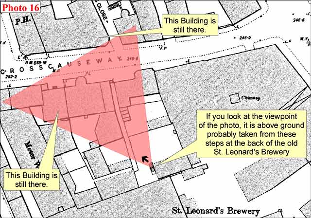
St Leonard's District Photos Photo 16 East Crosscauseway |

© Reproduced with acknowledgement to David Gordon, Old Town, Edinburgh
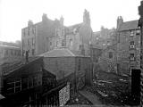
showing where the photograph above was taken from
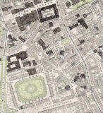
© This annotated Ordnance Survey 1:500 Town Plan of 1894 is reproduced with acknowledgement to Neil Lawrence. See 'Reply 2' below.
|
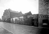
St Leonard's District - 1920s |
|
James Gibb James Gibson's sign can be seen in this photo. The 1930-31 edition of the Edinburgh & Leith Post Office Directory lists James Gibb as : "Property and Insurance Agent and Valuator, 4 West Nicolson Street" But where was this photo taken |
|
Collection of Photos The image above is taken from a collection of whole-plate negatives. The photos were probably taken around the 1920s. If you recognise this street, please email me. Thank you. Peter Stubbs: July 5, 2008 |
|
Reply |
|
Thank you to John Hadden, Edinburgh, who wrote about this photo. Please click on the thumbnail image below to enlarge the picture and see the details that John refers to below. John wrote: |
|
South Richmond Street? "In Photo 16, I recognised a building, the front of which can be seen through the gap of the other buildings, from Photo 23. I'm sure it's on East Crosscauseway to the West of Lamb's Close. We can see on both photos where the South East corner of that building has a 45 degree face. I'm sure this building still stands in East Crosscauseway today. In Photo 16, I think the tall building to the left of the photo, with three windows to each floor, is also still standing today. At the far left of photo 16, I think the two groups of chimney pots may possible be those on the building that straddles Cowan's Close in photo 12. That would place this photo as having been taken from the rear of what's currently 57 East Crosscauseway. John Hadden, Edinburgh: July 11, 2008 |
|
Reply 2. Neil Lawrence Fountainbridge, Edinburgh |
|
Thank you to Neil Lawrence for annotating a copy of his 1:500 Ordnance Survey Town Plan of Edinburgh, 1894, to show where the photograph above would have been taken from. Neil's annotated map is reproduced below the photograph at the top of this page. Acknowledgement: Neil Lawrence, Fountainbridge, Edinburgh: July 15, 2008. |
|
1891 Maps East Crosscauseway can be found in the lower-right corner of the South Side map and towards the upper-left corner of the St Leonard's map below |
|
More photos - Questions and Answers: Where is it? |
||