|
Edinburgh Transport Where is it? Is it Glasgow Road? ANSWER See Reply 6 below Ravelston Dykes Road ANSWER See Replies 7 + 9 below A8 Glasgow Road at Gogar |
The road to Glasgow?
© Reproduced by courtesy Lothian Buses plc
|
Questions |
|
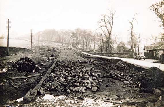
Possibly Glasgow Road Here is a deserted section of road. 1. Is it Glasgow Road?
Glasgow Road runs from Corstorphine (about 4 miles
west Edinburgh centre) 2. Does this photo show the laying the tramway tracks? |
|
Reply 1. George Murray |
|
Ingliston? "I don't think this has any tramway significance and would suggest that it is the construction of the improved A8 road to Glasgow which opened in 1928 as a 3 lane highway (right side, left side and suicide!!). This picture I would guess is looking east at Ingliston, the lodge house being to Norton House. The car predates 1928 so that fits. Glasgow Road within Edinburgh is a straight almost level road and the Trams reached to North Gyle about 1934 and the Maybury Feb 1937 none of this photo seem to fit in with that." George Murray: February 26, 2006 |
|
Reply 2. Patrick Hutton Edinburgh |
|
The new A8 "There are railway lines in the photo. There is a very clear line along the RHS of the new road works, and possibly another over to the left. But these aren't for trams - they are the contractor's temporary lines. I do know that narrow-gauge railways were used in the building of the new A8 in the late 20s/early 30s. Those in the photo look like 2 foot gauge, which was very common." Patrick Hutton, Edinburgh: February 27, 2006 |
|
NOTE:
The new A8 is the section of road that now runs past Edinburgh Airport.
|
|
Reply 3. Patrick Hutton Edinburgh |
|
The new A8 "I looked up some references. AM Carmichael Ltd (depot at Turnhouse) built some sections of the Glasgow Road, Eastern Section, 1924-34 I can't (yet) find confirmation that they built the Gogar section. (They did do Starlaw-Dechmont, Dechmont-Broxburn, also the Maybury-Barnton road and Telford Road.) They used 3 foot gauge steam locos on some sections. However, in this case, I think the gauge is narrower (scaled off the bucket), and maybe 2 foot. Perhaps just a simple tramway for moving material around. Quite possibly horse-drawn - this being just before dumper trucks became the norm." Patrick Hutton, Edinburgh: February 28, 2006 |
|
Reply 4. John Hadden Edinburgh |
|
Gogarburn "I would agree with George about the approximate location, but from OS Maps at the National Library of Scotland website. When looking east on the A8, the trees on the right would possibly take the viewer slightly nearer to Edinburgh. So, I think that the lodge on the right would be at Gogarburn. If you've got Google Earth installed, the attached placemark takes you pretty near to where I suspect the photo was taken from, except that the image is from an altitude of 158ft rather than human height." John Hadden, Edinburgh: February 27, 2006 |
|
NOTE: Gogarburn is on the A8, about a mile to the east of the turn-off for Edinburgh Airport. Unfortunately have not yet installed Google Earth on my PC, so I am not able to view the placemark that John sent to me. |
|
Reply 5. Ian Thomson Lake Maquarie, New South Wales, Australia |
|
Gogarburn "Regarding the Glasgow Road puzzle, my pal Norman from the Isle of Man and I, both brought up in the Corstorphine area of Edinburgh, are certain that this picture is outside the city boundary, so here goes - We believe that the picture is looking east on the Glasgow Road at at Gogarburn towards the Maybury. We think the minor road on right before the trees is to Ratho. Many a day I spent on the bike around this area, back in the 1940s and '50s. - Sunday trips for tomatoes to Gogarburn during the war - just me and the dog. So please, Peter, can you find some pics. from this wonderful area and old Corstorphine for an exiled scot from down under Ian Thomason, Lake Maquarie, New South Wales, Australia: March 15, 2006 |
|
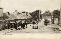
Ian: I'll see what old pictures I can find of the area, to add to the web site. Here is one of Corstorphine in the early 1900s - Peter Stubbs: March 15, 2006 |
|
Reply 6. Ken Watt Edinburgh |
|
After a wait of over seven years - since receiving Reply 5 - I believe that Ken Watt has now come up with an answer to where this photo would have been taken. Thank you to Ken for the comprehensive reply below. In fact, his reply included more maps and photos than I have been able to reproduce below. Ken says that he stands to be corrected, but I certainly believe that he has identified the correct location for this photo. Ken wrote: |
|
Not Glasgow Road "I stand to be corrected, but I think I may have an explanation which fits this photo. I know the Glasgow Road, but I couldn’t place the view of a hill in this photo as being part of Glasgow Road looking in either direction."
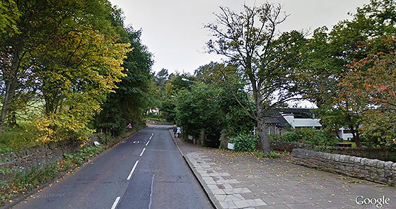
© Reproduced by courtesy Lothian Buses plc Ravelston Dykes "In fact I thought the view looked like the 1930s or 1940s road straightening at the western end of Ravelston Dykes in the 1930s or 1940s, probably commissioned by City of Edinburgh Transport Department (now Lothian Buses). - The line of trees is the 'Rest and Be Thankful' pathway up to Corstorphine Hill. - The Lodge looks like the Southern Lodge for Ravelston House, now Mary Erskine’s School for Girls. Here is a google Street View of the same scene, looking to the west along Ravelston Dykes Road from the near the traffic lights at the eastern end of the road where it joins Murrayfield Road and Ravelston Dykes: Looking to the west along The eastern end of Ravelston Dykes Road
© Google, This page has been taken from the Google Earth web site Reproduced with acknowledgement to Ken Watt, Edinburgh Ravelrig Manor "The original Ravelston Dykes ran on the playing field side of the School wall, in-between the avenue of trees extant today. When viewed close up, the gate piers are the same ones, and in the same position. If you look closely on the photo, a white gable ended property can be seen in the middle distance. This was Ravelrig Manor, demolished about 6 years ago and replaced with a huge modern residence for a consultant at Spire Murrayfield Hospital, I believe. Ravelrig had a white gable exactly like the one in your photo The wall on the left looks like it has been brought down in line with the new alignment, whilst on the golf course a line of trees now show where it once was." Map "Here is a map from 1826 showing the original realigning of the eastern end of Ravelston Dykes Road."
Map showing the realignment of
Ravelston Dykes Road
© Reproduced with acknowledgement to Ken Watt, Edinburgh The two tree-lined roads on the left-hand side of this map are: TOP: Ravelston Dykes Lane. CENTRE: The path to 'Rest and be Thankful'' on Corstorphine Hill. I suspect Ravelston Dykes Road was further straightened in the 1930s or 1940s, as shown in your photo." Ken Watt, Edinburgh: December 10, 2013 Ken describes himself as: "A former scruffy schoolboy who often walked this route home through 'the woods' in the 1970’s and ended up married to a Mary Erskine’s girl and still is, 27 years later." |
|
Reply 7. Simon Capaldi Sheriffhall, Midlothian, Scotland |
|
Thank you to Simon Capaldi who wrote: |
|
Ravelston Dykes? "I remember the original thread from 2006 and at the time I was convinced Glasgow Road was the answer. Notice how the wall gradually disappears as you go East. I imagine this was to reduce the surface level to eliminate blind spots and improve sight lines. I convinced myself that this is why the slight hill in the photo has disappeared although I have no answer as to why the lodge is not in my link. The Ravelston answer is very convincing too and I accept that version. This is what I like about your website so much! Any chance of you showing other photographs etc of this thread? Simon Capaldi, Sheriffhall, Midlothian, Scotland: December 20, 2012Hi Simon: |
|
Hi Simon: Glasgow Road or Ravelston Dykes Thanks for your reply. Having read Ken Watt's comments and looked at the photos and maps that he sent, the solution provided by Simon looked very plausible. However, let's see if we get any more responses. Photos, Maps and emails I'd like to be able to add more of Simon's maps and photos to the web site, but, unfortunately, I really don't have the time to do that. It took me a couple of hours to add Reply 6 (above) to the web site. I need to get back to replying to my emails which are still arriving faster than I am able to answer them. I've read them all and filed away those that don't need an answer, but, despite my spending over 6 hours a day (almost every day) on emails, I still have 533 in my 'in box' to be answered. More Photos and Maps I believe that the map showing the realignment of the road and Google Street View image that I included in Reply 6 (above) were probably the most relevant items to include. However, Ken also sent other items, including: - more aerial views showing the area concerned as part of a wider view. - old photos showing Ravelrig Manor, the house with the white gable that can also be seen on the road works photo. - recent maps showing the lodge that appears on the road works photo. Simon: I'll forward Ken's email and attachments to you now, in case you'd like to study any of the items. Peter Stubbs: December 22, 2013 |
|
Reply 8. Alisdair Flynn Middle Norton, Midlothian, Scotland |
|
Thank you to Alisdair Flynn for re-opening the discussion above. Alisdair wrote: |
|
A* Glasgow Road at Gogar "Sorry, but I'm not convinced with Ken Watt's theory. The scale looks all wrong.
© Reproduced by courtesy Lothian Buses plc I believe that this image is looking east towards Gogar on the A8 Glasgow road, and shows the upgrading of the road to dual carriageway. The gate house has been demolished but the stone piers remain along the south wall at precisely the golf course tee off adjacent to the wall. The land on the left shows a falling away down towards the Gogar burn and rising upwards to where there used to be some housing near Gogar church. I have walked along here and the proportions are correct." Alisdair Flynn, Middle Norton, Newbridge, Midlothian, Scotland: September 14, 2015 |
|
Reply 9. Ken Watt Edinburgh |
|
Thank you to Ken Watt for writing again. Ken wrote: |
|
Alisdair Flynn is Correct "I replied to your 'Where is it?' question about this photo in my Recollections 6 above, suggesting it may have in fact been Ravelston Dykes at Mary Erskine's School."
© Reproduced by courtesy Lothian Buses plc "I've only just chanced on this page again, and seen Reply 8 , above, from Alisdair Flynn. He replied that the scale was wrong in my theory. I agree. I started searching around the area he suggested and there are definite similarities. The 'hill' on the left struck me as odd, but from today's view, the construction of the new wider road has shrunk the hill by raising the road level. I have now concluded after checking positions and gate piers and the fact that the lodge house was demolished in 1948 that he is correct. He does after all live just along the road at Middle Norton." Gogar "I have seen the maps from NLS & Edin Council Atlas and they show that the Gogarburn North Lodge had a roof projection identical to the one in your photo. The lodge & gates are correctly positioned as well. I've searched the web but can't find any photos of it. The demolished Lodge was in between the 157 & 147 feet above sea level mark on the Glasgow Road on the 1895 NLS map, not the one opposite Golf Hall. That was Hanley East Lodge. Alisdair Flynn is on reflection correct. I think that this view is looking east from Gogarburn towards the RBS HQ Bridge. The scale is correct. I said I stood to be corrected and agree with Alisdair's opinion. Here are some photos** from Google street view of the piers, and excerpts from a PDF** from Edinburgh District Council Gogarburn Estate plans. Ken Watt, Edinburgh: 25 April 2016
|
|
** Maps and Plans Thank you, Ken for sending the Google street view and plans that you refer to in your final paragraph above. Unfortunately, I don't have the resources to add those to the EdinPhoto web site. I've found from experience that adding such items to the web site can be sometimes be quite time- consuming. However, I've kept those images on file, so that if anybody has a particular interest in them and contacts me, I'll be able to forward copies to them. Peter Stubbs, Edinburgh: 29 April 2016 |
|
Reply 10. Alisdair Flynn Middle Norton, Midlothian, Scotland |
|
Alisdair Flynn responded, thanking Ken Watt for his Reply 9 above. Alisdair wrote: |
|
Middle Norton on the Edinburgh -Glasgow road near Ingliston "I must admit to having a neighbour whose family have lived at Middle Norton since the early-1950s. As for myself, I always remembered the sharp angle of the stone dyke which seemed to be an astonishing accolade to the art of dry stone dyke building, as I travelled in my youth to my work at Whytock and Reid in Edinburgh from Kirkliston by Eastern Scottish buses. Old Photos of A8 "I have also discovered some old photographs on the St Andrews university site showing the A8 Glasgow road fuel station prior to 1950, which I found fascinating as some of its remains are still here nest door to me at Middle Norton. Thank you Ken Thank you, Ken, for keeping this thread alive. Alisdair Flynn, Middle Norton, Newbridge, Midlothian, Scotland: September 14, 2015 |
|
TRANSPORT |
|||||||
| Full Index |
Bus Tickets |
Railway Tickets |
|||||