Central Edinburgh

Edinburgh Castle  -  National Galleries  -  St Giles Church

1870

This map, by John Bartholemew, appeared in the Post Office Directory for 1870-71

Central Edinburgh  -  Edinburgh Castle and the National Galleries  -  1870 Map

earlier map         later map        zoom-in         zoom-out

1830       1840        1850        1860        1870        1917        2001    all (slow)    thumbnails

©  Copyright: For permission to reproduce, please contact peter.stubbs@edinphoto.org.uk


Zoom-out and Enlarge this map

PLEASE NOTE:  On the large map, you should be able to read all the street names but:

-  you will need to scroll across and down the map.

-  the map may be very slow to load.


Central Edinburgh  -  Key

Edinburgh Castle  -  National Galleries  -  St Giles Church

NOTE:  This key is based on the 1870 map

YELLOW = Princes St and the Royal Mile

     ORANGE= Hanover St and the Mound

GREEN = National Galleries

BLUE = Edinburgh Castle

RED = St Giles Church

©  Copyright: For permission to reproduce, please contact peter.stubbs@edinphoto.org.uk


Edinburgh

1860 - 1870

The changes over the ten years from 1860 until 1870 bring the streets of Edinburgh into line with the centre of the city as we know it today - over 130 years later.
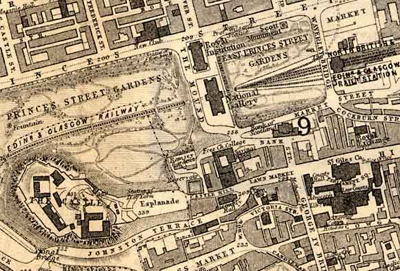
UPPER CENTRE:  The two galleries:

-  The Royal Institution (now named the Royal Scottish Academy) and

-  The National Gallery of Scotland

are still clearly shown, but now they have a road between them and a road (the Mound) alongside them.  The route of the Mound and Bank Street, up the hill, across the Royal Mile and into George IV Bridge is now more apparent.

Statues have been erected beside Princes Street, on either side of the galleries, in Princes Street Gardens.

CENTRE:  The Bank of Scotland in its prominent position, on high ground, at the centre of this map, has been enlarged since 1860.  This extension was welcomed, at least by RM Ballantyne who wrote:

"It was built in 1806 and the edifice has recently received very extensive and handsome additions.  These were much wanted, for the original building was by no means ornamental." 
[Photographs of Edinburgh]

UPPER  RIGHT:  More railway tracks have been added in East Princes Street gardens as the station has expanded. Waverley Bridge crosses the tracks, beside the station, and a new junction has been created where it joins Princes Street.  From this junction, there is a good view to the south towards the high buildings of the Old Town of Edinburgh. 

LOWER LEFT:  Edinburgh Castle - Some buildings have been added to Edinburgh Castle.  Others have been removed.  

LOWER RIGHT:  The top of West Bow has been named Victoria Street.  The alignment of this street has been changed where it joins George IV Bridge. 

More pages:  National Galleries


Edinburgh

1870s

The one remaining area of Edinburgh Old Town to be cleared of its slums was just off this map to the right hand side, between the Royal Mile and Chamber Street.

Archibald Burns, whose studio was at Rock House, was commissioned to take 26 photographs of different subjects within that area between Edinburgh University and the Cowgate.  Almost all the houses in this area were compulsorily purchased in 1869.

Demolition began around Christmas 1870. and replaced by Chambers Street and Guthrie Street.

The Minute Book of the Edinburgh Improvement Trust, on 7 Feb 1871, records discussion of a letter received:

"The architects beg to represent to the City Improvement Trustees that the photographs now exhibited on the walls of the Council Chambers have been prepared by Mr Burns under directions of some of the members of the works committee, without waiting for the formal approval of the Trustees as the Buildings were being rapidly demolished.

It is only necessary to refer to these photographs to be satisfied of the deep interest they excite and the faithful record of this historic part of the city which is in a few days will be entirely swept away.

The Account of Mr Burns embracing 26 photographs of different subjects is herewith submitted amounting to £16 7/-."


MAPS:  Full index

Outline Map of the British Isles © MAPS: Short Index with thumbnails


__________________