Edinburgh
1860
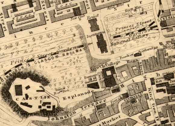
UPPER
CENTRE: There are now two galleries:
-
The Royal Institution (now named the Royal Scottish Academy) and
-
The National Gallery of Scotland.
UPPER
LEFT and RIGHT: The gardens at both sides of the galleries
are described here as Princes Street Gardens, as they are today.
The
name, Cleghorn's Nursery, has vanished. Trees have appeared in the
gardens. Some of these were removed in the 1990s, the result
of Dutch Elm Disease.
LOWER
LEFT: Edinburgh
Castle - The road running to the south of Edinburgh Castle has been
named Johnston Terrace, the name it is known by today.
LOWER
CENTRE: The building to the South of the two galleries,
also shaded dark on this map, is the newly built Free Church of Scotland
college, where DO Hill's painting of the Disruption hangs.
LOWER
RIGHT: The western end of the Old Town of Edinburgh.
Not so much detail is shown as on earlier maps. Leading to the
south from the High Street is King George IV Bridge, soon to become known as George
IV Bridge.
On
the left and right sides of George IV Bridge, respectively - the area in
the corner of this map - can now be found Edinburgh Central Library and
the National Library of Scotland. Neither of these had been built by
1860, so they do not appear on this map. More
pages: National
Galleries
|