|
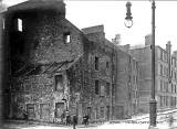
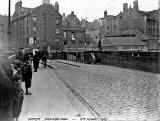
Sheriff Brae Leith |
Demolished 1915

© Reproduced with acknowledgement to Archie Foley, Joppa, Edinburgh
2011
© Copyright: Peter Stubbs - please contact peter.stubbs@edinphoto.org.uk Photo taken: January 25, 2011
|
Demolished 1915 |
2011 |
|
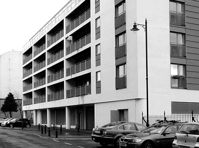
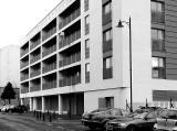
Comparison of 'demolished 1914' photo and 2011 photo The Corner of St Andrew Street and Sheriff Brae All the old buildings have survived. New buildings and cars have arrived. One of the old lamp posts has been positioned beside the new building. |
|
Looking down Sheriff Brae towards the corner of St Andrew Street and Sheriff Brae |
|
Location This view looks to the SE along Sheriff Brae towards the corner with St Andrew Street, now Parliament Street. The tree on the left-hand side of this 2011 photo is beside this street corner. The buildings on left of this row of houses, at the corner of the street, in the photo above are the same as the ones on the left-hand side of the photo below, taken from a few yards further to the east at the corner of St Andrew Street.
|
|
Sheriff Brae |
|
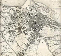
1870 Map Sheriff Brae is an extension to the west of Coalhill, the street beside what was the upper drawbridge over the Water of Leith at Sandport Place. The upper drawbridge can be seen on the 1870-71 map of Leith (below) immediately to the left of the letter 'L' of LEITH HARBOUR' printed along the centre of the Water of Leith.
|
|
Google Map St Andrew Street is one of the Leith streets that was re-named to avoid duplication of names when Leith and Edinburgh merged in 1920. St Andrew Street used to follow the course of what is now Parliament Street and the northern part of Giles Street 1. The corner in this photo is immediately to the left of the point on the 'A' arrow symbol on this Google map. 2. This photo of the upper drawbridge over the Water of Leith at Sandport Place was taken from immediately to the right of the point on the 'A' arrow symbol on the same Google map.
|

|
Acknowledgement: Archie Foley, Joppa, Edinburgh: January 5, 2010 The early photos above are from a series of photos posted onto boards in an old album that Archie Foley acquired a few years ago. Archie believes that these are likely to be official photos that probably once belonged to Leith City Council. |
|
Reply 1. Frank Ferri Newhaven, Edinburgh |
|
Frank Ferri added: |
|
Shirra Brae "To this day, many old Leithers still refer to Sheriff Brae (the road linking Mill Lane and Coal Hill) as 'Shirra Brae'. The Sheriff "It was named after the wealthy Leith Merchant, Sir John Logan of the Logan’s of Coatfield, who became Sheriff of Leith. His son, James, was knighted by king James IV and became Deputy Sheriff. Sir John bestowed the lands to his son, along the Water of Leith from Bridge End (Sandport Place) to Ballantyne Rd and Leith Mills at North Fort. Mill lane was just then a rough walkway lined with hawthorn bushes. Sir John’s manse was on the site now occupied by St Thomas’s church." Frank Ferri, Newhaven, Edinburgh: January 28, 2010 |