|
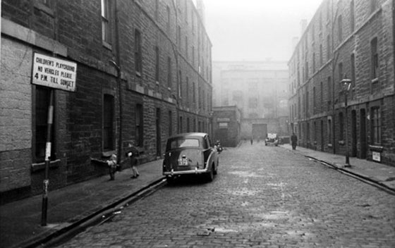
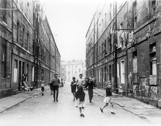
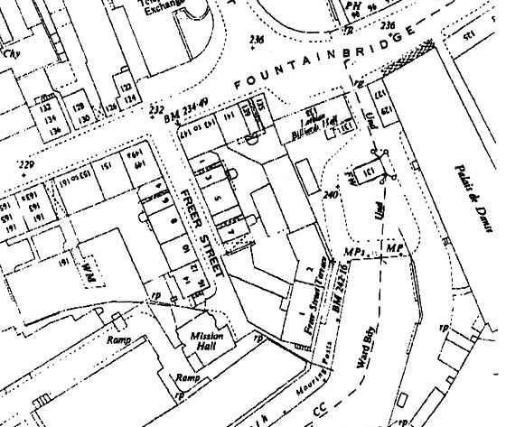
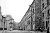
Photography in Edinburgh by Robert Blomfield Where is it? ANSWER: Freer Street, Fountainbridge Photo 14. A Play Street in Edinburgh with 'razor edge' Triumph and lamp post - 1960
© Robert Blomfield Photo taken 1960 |
|
Photography in Edinburgh by Robert Blomfield |
|
Photo 14 Where is it? This is one of a large collection of photos taken by Robert Blomfield in Edinburgh between 1956 and 1967. Robert's brother, John is in the process of scanning and cataloguing the photos. He'd like to discover where this photo was taken. If you recognise the location, please email me , then I'll pass on the news to John. Thank you Peter Stubbs, Edinburgh: March 16, 2013 |
|
Photo 14 Replies |
||
|
1. |
Simon Capaldi
|
Jameson Place Pilrig |
|
2. |
Peter Stubbs
|
PROBABLY NOT Jameson Place Pilrig |
|
3. |
Peter Stubbs
|
NOT Jameson Place Pilrig |
|
4. |
Neil Lawrence
|
NOT Jameson Place Pilrig |
|
5. |
Forbes Wilson
|
Bedford Street Stockbridge |
|
6. |
Peter Stubbs
|
NOT Bedford Street Stockbridge |
|
7. |
Terry Cox
|
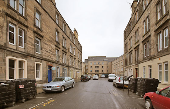
Freer Street Fountainbridge |
|
8. |
Peter Stubbs
|
Bedford Street Stockbridge |
|
9. |
Bryan Gourlay
|
Bedford Street Stockbridge |
|
10. |
Simon Capaldi
|
NOT Freer Street Fountainbridge |
|
11. |
Allan Dodds
|
Heriot Hill Terrace Canonmills |
|
12. |
Peter Stubbs
|
NOT Heriot Hill Terrace Canonmills |
| 13. |
Neil Lawrence
|
Freer Street Fountainbridge |
| 14. |
Betty Hepburn
|
Freer Street Fountainbridge |
|
15. |
Simon Capaldi
|
Freer Street Fountainbridge |
|
16. |
John Fraser
|
NOT Jameson Place Pilrig |
|
17. |
Stuart Lyon
|
NOT Bedford Street Stockbridge |
|
18. |
John Moyes
|
Freer Street Fountainbridge |
|
19. |
Thorntree Street Leith |
|
|
20. |
Terry Cox
|
Freer Street Fountainbridge |
|
21. |
Peter Stubbs
|
The Discussion Continues |
|
22. |
Thorntree Street Leith |
|
|
23. |
Freer Street Fountainbridge |
|
|
My Conclusion
Photo 14 was taken at Freer Street, Fountainbridge |
||
|
Photo 14 Reply 1. Simon Capaldi Sheriffhall, Midlothian, Scotland |
|
Thank you to Simon Capaldi for sending a quick reply. Simon wrote: |
|
Jameson Place "This photo is of Jameson Place off Leith Walk. There used to be an old depot at the end of the street. You can see it at the back of this photo." Simon Capaldi, Sheriffhall, Midlothian, Scotland: March 16, 2013 |
|
But see further replies below |
|
Photo 14 Reply 2. Peter Stubbs Edinburgh |
|
Is this Jameson Place? Unlikely I visited Jameson Place this afternoon and compared it with Robert Blomfield's photo taken in 1960. The buildings that I saw at the west end of the street, close to its junction with Lieth Walk were built in the late 19thj century. They have stone plaques giving the dates '1895' and '1896'. The buildings in Robert Blomfield's Photo 1 below also seem likely to be 19th century, but the style of stonework does not seem to match the buildings in Photos 14a and 14b, so I believe that Robert's photo must be of a different street. Below is a copy of Robert's photo, followed by two photos that I took this afternoon. Photo 14. 1960
© Robert Blomfield Photo taken 1960 Photo 14a. 2013 West end of the street (by junction with Leith Walk) - looking east
© Copyright: Peter Stubbs Photo taken 17 March 2013 Photo 14b. 2013 Centre of the street - looking east
© Copyright: Peter Stubbs Photo taken 17 March 2013 |
|
Peter Stubbs: March 17, 2013 |
|
Photo 14 Reply 3. Peter Stubbs Edinburgh |
|
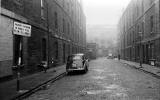
Is this Jameson Place? No I took Photo 14c below near the east end of Jameson Place on 18 March, the day after taking photos 14a and 14b above. Photo 4 shows that in Jameson Place: - there are ribbed lintels with overhangs above the windows on the floor above the ground floor, on both sides of the street. - many of the windows on both sides of the street are in pairs. Neither of these features can be found on Photo 1 below, so I conclude that Photo 1 is not a photograph of Jameson Place. Photo 14. 1960
© Robert Blomfield Photo taken 1960 Photo 14c. 2013 East end of the Jameson Place, near the junction with Leith Walk - looking east
© Copyright: Peter Stubbs Photo taken 18 March 2013 |
|
Photo 14 Reply 4. Neil Lawrence Fountainbridge, Edinburgh |
|
Neil Lawrence agrees that this photo is not Jameson Place Neil wrote: |
|
Not Jameson Place "I can't agree that this photo was taken in Jameson Place. The banding of stones along the front of the tenements doesn't match that street. I'm not sure where it actually is yet, but I'm working on it." Neil Lawrence, Fountainbridge, Edinburgh: March 19, 2013 |
|
I agree, Neil. I think it would be safe to assume that the 1960 photo was not taken in Jameson Place. Peter Stubbs, Edinburgh: March 24, 2013 |
|
Photo 14 Reply 5. Forbes Wilson near Guildford, Surrey, England |
|
Thank you to Forbes Wilson who wrote: |
|
Not Jameson Place "This phot o bears a striking similarity to Bedford Street in Stockbridge." Forbes Wilson, near Guildford, Surrey, England: March 23, 2012 |
|
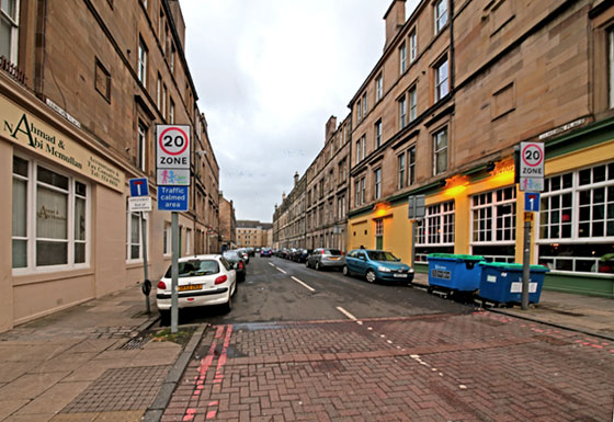
Comment in response to Reply 5. Thank you to Forbes Wilson for also sending me a photograph of Bedford Street, Stockbridge, to compare with Robert Blomfield's 1960 photo. I'll add the picture that Forbes sent to the EdinPhoto web site if I can get copyright permission to add it to the site. However, my first impression on seeing the photo that Forbes sent to me is that the buildings at the end of the street in his photo don't match the buildings at the end of the street in the 1960 photo. I believe that Photo 10 is of Bedford Street, Stockbridge. Photo 10 However, evidence seems to be growing in support of the argument that Photo 14 is of Freer Street, Fountainbridge. Photo 10 Peter Stubbs, Edinburgh, April 4, 2013 |
|
Photo 14 Reply 6. Peter Stubbs Edinburgh |
|
Not Bedford Street After reading the comments from Forbes Wilson in his 'Reply 5' above, I photographed Bedford Street in March 2013 (14d below) . However, I see no evidence of it being the same street as in the 1960 photo (14 below). - Photo 14 shows tenements on both sides of the street.. - Photo 14d shows tenements on just one side of the street and newer housing on the other side, but: - In Photo 14b, there are gardens between the tenements and the street. - The stonework and windows of the tenements appear to be different in the Photos 14 and 14d. My conclusion: The street in the 1960s photo is NOT Bedford Street. Photo 14. 1960 Is this a photo of Bedford Street, Stockbridge? I think 'No'. See my comments about photos 14 and 14d above.
© Robert Blomfield Photo taken 1960 Photo 14d. 2013 Looking to the south up Bedford Street, Stockbridge
© Copyright: Peter Stubbs Photo taken 25 March 2013 UPDATE Please see Reply 8 below |
|
Peter Stubbs, Edinburgh: March 27, 2013 |
|
Photo 14 Reply 7. Terry Cox Fairmilehead, Edinburgh |
|
Thank you to Terry Cox who wrote: |
|
Is it Freer Street? "I'm waiting to be shot down in flames, but this photo looks a bit like Freer Street, where Asa Wass' office used to be, just off Fountainbridge. I can't find any pictures of Freer Street, and it's been gone for about 40 odd years, so I'm relying on memory. Someone might be able to prove (or disprove) this, and there are probably some of your correspondents who will know Freer Street better than I do, so I only punt it as a possibility." Terry Cox, Fairmilehead, Edinburgh: March 27, 2013 |
|
Photo 14 Reply 8. Peter Stubbs Edinburgh |
|
Bedford Street? Perhaps I was too hasty in ruling out the possibility of this street being Bedford Street. Having found another photo of Bedford Street, taken in the early-1960s, already on the EdinPhoto web site (which I've numbered 14e below) , I've reached the conclusion that: a) The style of the tenements on the right-hand side of Photo 14 is a good match for those on the right-hand side of 14e. b) There is no match in Photo 14 for the house with the gable in Photo 14e, but perhaps Photo 14 was taken from closer to the far end of the street. c) The building at the far end of the street still puzzles me. There appears to be a different building there in all three photos! c) The style of the tenements in Photo 14 is a good match for those on the in 14f. The buildings in the background of these two photos also appear to match. d) Photo 14d looks up Bedford Street, but I believe that the tenements on BOTH sides of Bedford Street must have been demolished. What we are seeing on the right-hand side of this picture 14d is the the tenements in Dean Park Street and their back gardens. Conclusion Photo 14 may well be of Bedford Street. But, what is the building at the end of the street in this photo? In his reply about Photo 10 (numbered 14f below) Neil Lawrence mentions that he has been able to match these buildings against a recent Google Streetview. I'll see if I can discover more about this Streetview from Neil. Peter Stubbs, Edinburgh: March 30, 2013 |
|
Photo 14. 1960 Where is it? See my comments about photos 14, 14e and 14d above.
© Robert Blomfield Photo taken 1960 Photo 14e. Bedford Street, Stockbridge, View from Dean Park Street End
© Reproduced with acknowledgement to Eddie Duffy, Fox Covert, Edinburgh Photographer not known Photo 14f.
Children playing and washing hanging
out in a Play Street - 1964
© Robert Blomfield Photo taken 1964 Photo 14d. 2013 Looking to the south up Bedford Street, Stockbridge
© Copyright: Peter Stubbs Photo taken 25 March 2013 |
|
Update to Reply 8. Photo 14 The building at the end of this street in Photo 14 looks industrial to me, with its large squarish windows and large doorway facing the end of the street. Can anybody tell me if there was once some industry there? Peter Stubbs, Edinburgh: March 30, 2013 |

|
Photo 14 Reply 9. Bryan Gourlay Biggar, Lanarkshire, Scotland |
|
Thank you to Bryan Gourlay for responding to my comments in 'Reply 8' above. Bryan wrote: |
|
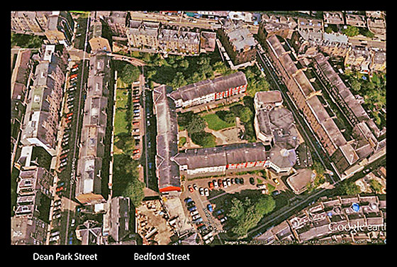
Bedford Street All Tenements Now Demolished "I'm sure you are right saying the tenements on both sides of Bedford Street have been demolished. My great, great grandparents lived in Bedford Street in the 1850s and my great grandfather was born nearby in Allan Street which has also been knocked down apart from a few yards close to Raeburn Place. Here is a Google Earth picture in which you can see a recent view of Bedford Street: Bedford Street, Stockbridge is centre-left in this view
©
Google Earth web site, with acknowledgement to Bryan Gourlay
Today's Bedford Street is as you describe it in 14d, with the back gardens of Dean Park Street on one side and newish buildings on the other." Bryan Gourlay, Biggar, Lanarkshire, Scotland: March 28, 2013 |
|
In the photo above, Dean Park Street and Bedford Street are the two streets running vertically through the picture, above the street names. (I got a new version of Photoshop today and have still to learn how to draw arrows on maps!) The alignment of Bedford Street when it had tenements on either side was more diagonal, as the map below shows. Dean Park Street leads vertically down from the top of this map. When travelling down Dean Park Street, Bedford Street is the first street on the left (i.e. towards the top-right corner of the map. Bedford Street, Stockbridge is just to the right of the centre at the top of this map.
© Peter Stubbs Please contact peter.stubbs@edinphoto.org.uk for permission to reproduce Peter Stubbs, Edinburgh: March 29, 2012 |
|
Photo 14 Reply 10. Simon Capaldi Sheriffhall, Midlothian, Scotland |
|
Thank you to Simon Capaldi for for writing again. Simon wrote: |
|
Not Freer Street? "I would suggest that this photo is definitely not Freer Street. Freer Street had a canal at the end and the houses were two-stories tall." Simon Capaldi, Sheriffhall, Midlothian, Scotland: March 28, 2013 |
|
Not Freer Street? Hi Simon: I don't remember Freer Street myself. However there are others who remember it and have told me about it. They remember the tenements being more than two stories high. In ' Recollections 14 ' below, I refer to the book: "Water Under The Bridge". There is a copy of a painting of Freer Street on the front of that book. It also shows the tenements in Freer Street to be several (4) stories high. If photo 14 is of Freer Street, it may be looking to the north down DFreer Street to the main road, Fountainbridge. i.e. the photographer may have had his back to the canal when he took Photo 14. |
|
Photo 14 Reply 11. Allan Dodds Nottingham, Nottinghamshire, England |
|
Thank you to Allan Dodds who wrote: |
|
Is it Heriot Hill Terrace? "This photo looks like Heriot Hill, opposite the Ritz in Rodney Street. You have a picture of Heriot Hill Terrace on the EdinPhoto web site." Terry Cox, Fairmilehead, Edinburgh: March 28, 2013 |
|
Photo 14 Reply 12. Peter Stubbs Edinburgh |
|
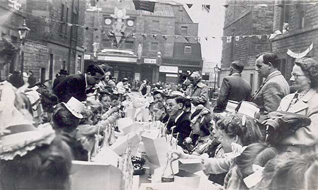
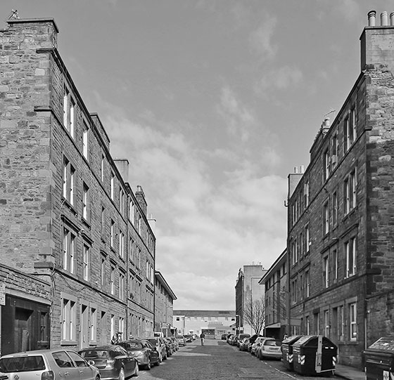
Here are: - Photo 14, which we are trying to identify, followed by - Photo 14g, a picture of the Coronation Party in Heriot Hill Terrace that Allan Dodds mentions in 'Reply 11' above. - Photo 14h, which I took in Heriot Hill Terrace on I cannot see enough detail in the background of Photo 14g to decide whether or this looks like same street as is in Photo 14. However, the back of a road sign can be seen near the right-hand side of Photo 14g which looks as if it may be 'Play Street' road sign seen in Photo 14. There is a Incidentally, I think I recall seeing a 'Play Street' road sign near the Rodney Street end of Heriot Hill Terrace a few years ago, but it has now been taken away. Conclusion The style of buildings in Photos 14 and 14h appear to be different. The positions of the windows and lintels in the two photos do not match. So Photo 14 appears NOT to be Heriot Hill Terrace. Peter Stubbs, Edinburgh: March 30, 2013 |
|
Photo 14. 1960 - Where is it?
© Robert Blomfield Photo taken 1960 Photo 14g. 1953 - Heriot Hill Terrace Looking to the west towards The Ritz cinema in Rodney Street.
© Reproduced with acknowledgement to Jim Duncan and Anne Simons Photo taken: June 2, 1953 Photo 14. (again) 1960 - Where is it?
© Robert Blomfield Photo taken 1960 14h. 2013 - Heriot Hill Terrace View looking east from Rodney Street.
© Copyright: Peter Stubbs - please contact peter.stubbs@edinphoto.org.uk Photo taken March 28, 2013
|
|
Photo 14 Reply 13. Neil Lawrence Fountainbridge, Edinburgh |
|
Neil Lawrence wrote: |
|
Photo 14.
© Robert Blomfield Photo taken 1960 Neil wrote: Freer Street Fountainbridge "This photo could be Freer Street because these features.: - The buildings at the end of the road - The jutting out building on the left and - Tenements, longer on the right-hand side All these features match buildings that I have seen that were next to the canal." Neil Lawrence, Fountainbridge, Edinburgh: March 28, 2013 |
|
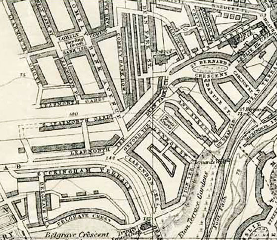
1894 Thank you to Neil Lawrence for sending me this extract from a large-scale map of the area around Freer Street:
© Ordnance Survey 1:500 Town Plan of 1894 is reproduced with acknowledgement to Neil Lawrence, Fountainbridge, Edinburgh |
|
Reply 14 . Betty Hepburn ( née Boland) Waikanae, Kapiti Coast, New Zealand |
|
Thank you to Betty Hepburn who wrote |
|
Freer Street? "Like Terry Cox, my hubby, Peter, thinks this is of Freer Street, Fountainbridge. Peter's Granny Hepburn lived there. I may be wrong, but Peter's mother, Annie Hepburn (née Campbell) and his Aunt Begbie (née Campbell) also believe that the photo would have been taken in Freer Street." We have a copy off the Book "Water Under The Bridge" . On the front cover, there is an artist's drawing which shows a view of Freer Street taken from the bottom of the street. Freer Street Church Hall was there. Hubby attended Sunday School there. The book is very interesting. It has lots off wee stories and photos donated from the locals." Betty Hepburn (née Boland), Waikanae, Kapiti Coast, New Zealand: March 17, 2012 |
|
Painting - 1953 I also have a copy of the book the book, "Water Under The Bridge". The book has a cover illustration is of a painting by George Brown titled: "The Queen's Visit to Freer Street, 1953" . The scene in this painting looks to the north down Freer Street to the main road, Fountainbridge. The Royal horses and coaches are passing along Fountainbridge past the end of Freer Street. The housing in George Brown's painting looks to me to be a good match for Photo 14 above. However: - the painting looks to the north along Freer Street towards the main road, Fountainbridge, but - as the map sent by Neil Lawrence in 'Reply 13' above shows, the photo looks to the south along Freer Street, towards the canal. I'll add a copy of this painting to the EdinPhoto web site if I am able to contact the artist and get his permission to add it to the web site. Freer Street My conclusion at this stage is that it seems very likely to me that the scene in Photo 14 is Freer Street . Peter Stubbs, Edinburgh: March 31, 2013 |
|
Photo 14 Reply 15. Simon Capaldi Sheriffhall, Midlothian, Scotland |
|
Thank you to Simon Capaldi for writing again, following up the comments he left in his 'Reply 10' above. Simon wrote: |
|
Freer Street? " I must do an 'about turn'. My friend confirms that this photo is of Freer Street, looking south: He was born there in 1932 at No. 3. The mission hall served as a nursery during the week and as a Sunday School on Sundays. The steps on the left led to a terrace next to the canal. I think the late 1800's map has the hall slightly off centre." Simon Capaldi, Sheriffhall, Midlothian, Scotland: March 28, 2013 |
|
Photo 14 Reply 16. John Fraser Inch, Edinburgh |
|
Thank you to John Fraser for sending me a little information about Jameson Place and for confirming, as others have done above, that this photo is not of Jameson Place. John wrote: |
|
Not Jameson Place "This photo is definitely not Jameson Place." "Although it looks similar: - at the end of the street in Jameson Place was John Gibson and Son Ltd. Motor Engineers. It was originally an open yard, but had been roofed over. I worked there 1951 to 1965, but moved to their new building in Lorne Street. - At the end of the street at Leith Walk was a Post office on one corner and a pub on the other. - Lorne Street Primary school playground was on the left hand side looking East. John Fraser, Inch, Edinburgh: 9 May 2013 |
|
Not Jameson Place Agreed, John. the photo is not of Jameson Place, Pilrig. It is of Freer Street, Tollcross.
Peter Stubbs, Edinburgh: May 9, 2013
|
|
Photo 14 Reply 17. Stuart Lyon Blackford, Edinburgh |
|
Thank you to Stuart Lyon who wrote: |
|
Not Bedford Street "I just thought I would put my tuppence worth in on this debate. My Granny lived in Bedford Street and I spent a lot of time there in the 1950s. I cannot recall any building in Bedford Street that jutted out such as the one in the picture under discussion.
Stuart Lyon, Blackford, Edinburgh: 5 April 2013 (with apologies
to Stuart for
|
|
Not Bedford Street Agreed, Stuart. the photo is not of Bedford Street, Stockbridge. It is of Freer Street, Tollcross.
Peter Stubbs, Edinburgh: May 10, 2013
|
|
Photo 14 Reply 18. John Moyes |
|
Thank you to Stuart Lyon who wrote: |
|
Freer Street "The photograph is definitely Freer Street and it was taken from the East side of the Street. The building in the distance is the Uniroyal Tyre Factory." Freer Street Terrace "Freer Street was a cul de sac, but running off it was Freer Street Terrace. That was on the East side of the Street (left hand side as you look at the photograph), right at the very bottom of the Street with the Union Canal immediately behind it. It was accessed by two short flights of steps and there were two tenements in the Terrace." The Tenements "At the time that the photograph was taken I worked in the National Assistance Board and Freer Street and Freer Street Terrace were part of my territory. I visited there almost every day so I knew it very well indeed.. The tenements in the Street, and even more so the Terrace, were in very bad condition. It was necessary to be very careful when going to any of the houses in the Terrace. The wooden stairway was almost completely rotten and keeping very close to the wall was the only comparatively safe way up. Freer Street itself was not quite so bad, but still far from pleasant. Most of the houses in the tenements were 'Room and kitchen' (some had two rooms). Even in the 1960s few had running hot water and there were almost no baths, only WCs." The Residents " The people living in Freer Street and Freer Street Terrace were in three broad groups: - A few were working families (most of the men worked in the Uniroyal factory). - A much larger number were pensioners who had lived there mostly for a long time. - The third group were more transitory residents and most of them were long-term unemployed; a few were single parents. People generally moved into Freer Street and Terrace because there were very few other places for them to go. As an aside, many of them moved quite frequently between Freer Street and Bedford Street and Dean Street in Stockbridge." Bedford Street Some Houses in Good Repair "I shouldn’t leave you with the impression that all the houses in Freer Street were dire. Many were well kept and comfortably furnished, but the staircases and the various common areas were all in poor shape. Those who flitted in and out had by far the worst of it. Their houses were almost all in bad repair and squalid by any standards. They were usually let 'furnished', something of an exaggeration." John Moyes: September 17, 2014 |
|
Photo 14 Reply 19. Livia Dyckhoff Edinburgh |
|
Thank you to Livia Dyckhoff who wrote: |
|
Thorntree Street "I am positive that this is not Freer Street, but the cul-de-sac end of Thorntree Street. (I used to live down the far end on the right hand side from 1998 until last year.) - EH6 8PU. - This Google Street View shows a 'Play Street' sign, still up. - In the far distance, it looks like the bingo hall. - Also, there used to be an old warehouse-like building. It can be sen in the picture above. - The line of the windows, including stepping down a bit as you go down the street, looks like a match - Even the painted shop corner at the extreme left of the picture matches up." Livia Dyckhoff, Edinburgh: September 29, 2014 |
|
Photo 14 Reply 20 Terry Cox Fairmilehead, Edinburgh |
|
Thank you to Terry Cox who emailed me after reading Reply 18 above (and before I had chance to add Reply 19 above to the web site). Terry wrote |
|
Freer Street "I'm Fair chuffed to see that the photo turned out to be Freer Street, as I suspected. It means that maybe my memory isn't as shaky as I thought it was Terry Cox, Fairmilehead, Edinburgh, October 3, 2014 |
|
Photo 14 Reply 21 Peter Stubbs Edinburgh |
||||||||||||||||||||
|
Where is it?
© Robert Blomfield Photo taken 1960 The Discussion Continues "I thought that discussion of this photo had probably come to an end in May 2013, but it has started up again now! So far, 20 replies have been received in support of and against a number of streets. See the results below in which I've listed the streets in the order that they were suggested and allocated SCORES = Number of 'YES' s LESS Number of 'NO' s ***
Freer Street has come out as the clear favourite, but not everybody agrees. See Reply 19 above." Peter Stubbs, Edinburgh: October 3, 2014 *** The results above have now been updated to include Reply 22 below. |
|
Photo 14 Reply 22. Livia Dyckhoff Edinburgh |
|
Thank you to Livia Dyckhoff for writing again telling me of correspondence on this City Cycling Edinburgh forum page: |
|
Not Thorntree Street BUT Freer Street " Regular contributor, kaputnik makes the following comments, supporting his view that the photo above is of Freer Street, not Thorntree Street. (I've added my own comments are in brackets.) - T he street in this photo appears to run downhill at a faster rate than Thorntree Street (based on how frequently the stretcher courses in each block drop a level). - The building at the end matches closely with the general profile and look of the Castle Mills rubber works, which would have been at the end of Freer Street at this time. At the end of Thorntree Street was the Capitol Cinema (now Mecca bingo). It's profile would have been the same in the old photo as it is now, but I don't think it matches. - There was a low building at the end of Freer Street which jutted out slightly, this can be corroborated on the maps. No such building existed on Thorntree Street, a back wall of a yard was where the new houses are now, but they followed the line of the tenements. Also, there was a gap on the left between the tenements and the factory where there was a mission hall. - The number of blocks of tenements match the map for Freer Street, as does the left hand being shorter than the right hand." Livia Dyckhoff, Edinburgh: October 3, 2014 |
|
Photo 14 Reply 23. David Millan |
||||||||||
|
Thank you to David Millan for writing about this photo. David wrote: |
||||||||||
|
Freer Street Sweetie Shop "This photo is, without doubt, Freer Street. I was born in 169 Fountainbridge in 1945, and spent many evenings of my childhood standing under the lamppost on the right of the picture where a wee sweetie shop was. You can see the shop window clearly." The End of the Street "The building at the end of the street is North British Rubber Mill. The entrance there was never used to my knowledge." At the end, to the left of the picture, there was the passage way to Freer Street Terrace. This was described by Harold Wilson as “the worst slum in Europe” at the time of his visit. To the right at the end was St Cuthbert’s Church Mission. I went to the Sunday School there." Another Photo "There is a photograph in the archives of the Central Library of Freer Street, taken from the other end of the street. In that, the telephone exchange building on the corner of Gardners Crescent & Fountainbridge can be clearly seen. I wonder if it was taken by the same photographer at the same time. The Archive people didn’t know anything about it until I identified the location for them." David Millan: December 13, 2014 |
||||||||||
|
Hi David: Thanks for your comments. Yes, I'm convinced that this photo is of Freer Street. If I update the table in Reply 21 above to include the comments in Replies 22 and 23 and my own views, the results become: *
Peter Stubbs, Edinburgh, December 14, 2014 |