|
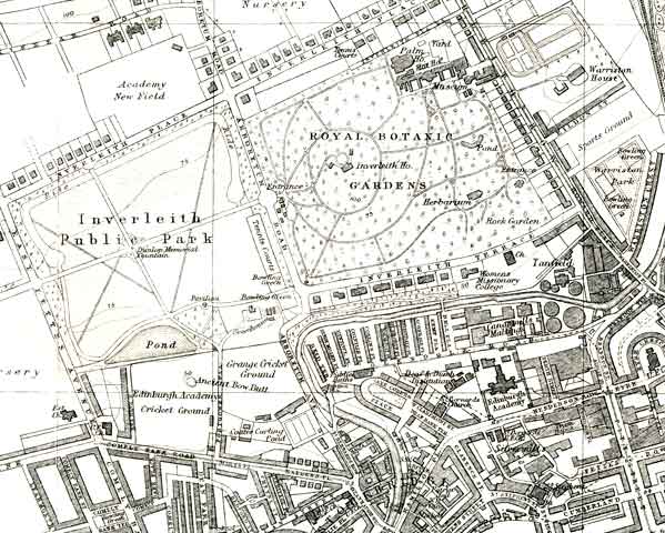
Inverleith Inverleith Park, Royal Botanic Garden and Water of Leith 1925 |
Extract from an Ordnance Survey Map
© For permission to reproduce please contact peter.stubbs@edinphoto.org.uk
This is an extract from Bartholomew's Post Office Plan of Edinburgh & Leith
|
Inverleith |
|
Many prominent landmarks on this map of Inverleith still exist today: |
|
- Inverlieth Park (though on this map it has a 'Ride' (presumably for horses) shown in the northern section of the park. |
|
- Royal Botanic Gardens (with its large Victorian Palm House, being refurbished in 2004-05). |
|
- Comely Bank Road running from left to right in the lower-left corner of the map, from Comely Bank to Stockbridge. On the northern side of this road, and seen more clearly on the enlarged copy of this map, are an Ancient Bow Butt in Edinburgh Academy cricket ground and Coates Curling Pond in the land to the east of the cricket ground. |
|
- Glenogle Road running parallel to the southern boundary of the Royal Botanic Gardens, on the southern side of the Water of Leith. Between the Water of Leith and Glenogle Road are a short distance to the south of the gardens. Between Glenogle Road and the Water of Leith, also more clearly on the enlarged copy of this map, are: - The Colonies, co-operative housing - Canonmills Maltings (now demolished and replaced by new housing) - Tanfield Gas Works (now demolished and replaced by The Standard Life Assurance Company administrative offices and computer centre). |
|
- Henderson Row and the Silvermills area in the lower-right corner of the map. The Henderson Row tram depot became a Police vehicle garage and has now converted to an Insurance company office. The small businesses in the Silvermills area have now gone and are being replaced by new housing on the southern edge of the Edinburgh New Town. |
|
Inverleith Park |
|
Thank you to Douglas Beath, Tasmania, Australia who comments: |
|
"I remember the 'Ride' and you're right. It was a sawdust- or bark-surfaced track about six meters wide, between the perimeter trees and a white-painted single-rail fence round the grassed area (part of which was turned over to vegetable allotments during the war)." |
|
Royal Botanic Garden |
|
Small maps 1925 OS Map 1870 1909 1970 2012 |
|
Large maps 1925 OS Map 1870 1909 1970 2012 |
|
Maps: All Edinburgh Districts: 1870 1915 1925 1940 1955 2001 |
|
|
Map Index: Full Index |
Map Index: Short Index + thumbnails |