|
St James Square Near the East End of Princes Street, Edinburgh Aerial Views Photo 1 - 1958 Photo 2 - Recent Photo 3 - 1958 + Key Photo 4 - Recent + Key |
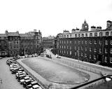
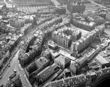
1958 Aerial View
Looking SW over St James' Square towards the GPO

© Scotsman Publications Ltd.
Click
here for web site details. Licensed by
Scran,
Photo 99990859
Scran 000-000-051-707-R
Photo published: Aug 12, 1958
Recent Aerial View
Google Image - published 2012
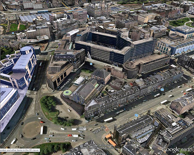
© Google. This page has been taken from the Google Earth web site, with acknowledgement to Alan Mark, Warriston, Edinburgh
1958 Aerial View + Key
Looking SW over St James' Square towards the GPO
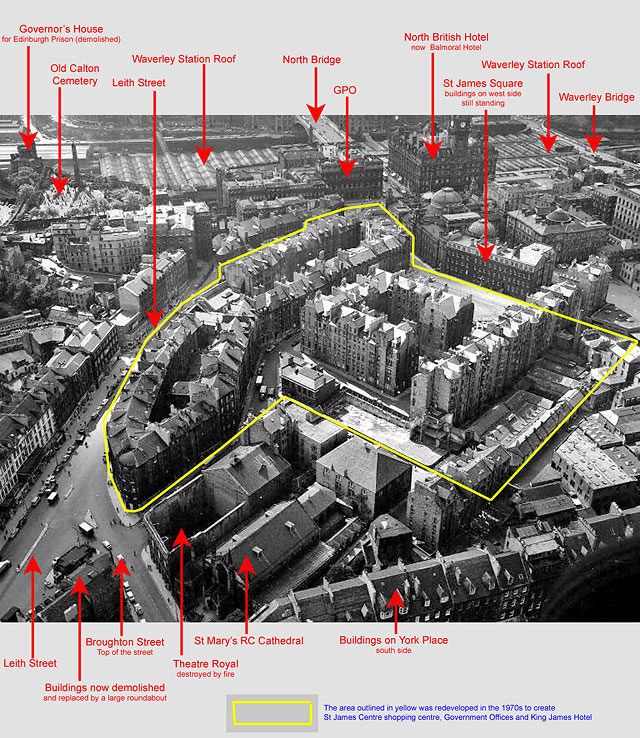
© Scotsman Publications Ltd.
Click
here for web site details. Licensed by
Scran,
Photo 99990859
Scran 000-000-051-707-R
Key added by Peter Stubbs Photo published:
Aug 12, 1958
Recent Aerial View + Key
Google Image - published 2012
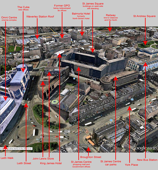
© Google. This page has been taken from the Google Earth web site, with acknowledgement to Alan Mark, Warriston, Edinburgh
Key added by Peter Stubbs
|
and see this photo with a key |
|
Aerial Views of |
|
Photos Location Photo 1 includes St James Square - the open area near the NE boundary of the land enclosed by the yellow line that was developed to create the St James Centre shopping mall, government offices and King James Hotel. At the bottom centre is St Mary's Roman Catholic Cathedral, and beside it stands the shell of the Theatre Royal, destroyed by fire in 1946. This photo was published in the Edinburgh Evening News on August 12, 1958. Photo 3 is the same as Photo 1, but with a key added. Demolition and Redevelopment Almost all of the buildings in the St James Square area were demolished around 1970, to allow the area to be redeveloped as the Saint James' Centre Government Offices, hotel and shopping complex. Thank you to Alan Monk for emailing me to remind me that the buildings on the right hand side of Photos 1 and 3 above (those with the light upper floor, on the west side of the square) were not demolished around 1970, and are in fact still standing today.* This prompted me to take some photos of the area as it is today. I hope to add these to the web site soon. * Acknowledgement: Alan Monk, Warriston, Edinburgh: June 13, 2012 |
|
Photos Photo 2 above is the image now (at 2012) being shown on Google Earth for St James Centre and the surrounding area. Thank you also to Alan Monk for contacting me again and sending a copy of this photo to me.** The GPO in this photo appears to be covered in material and still being redeveloped as new offices. This suggests to me that the photo would probably have been taken a few years before 2012. Photo 4 is the same as Photo 2, but with a key added. ** Acknowledgement: Alan Monk: June 25, 2012 |
|
Close up view of |
|
1956 Please click on the thumbnail image below to see another view of St James Square. This view is a close-up of the buildings on the west side of the square, with the clock tower of the North British Hotel in the background. This photo was published in the Edinburgh Evening News on May 3, 1956: |