|
Edinburgh Airport Six miles to the west of the centre of Edinburgh |
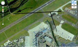
Google Earth View showing the approximate line of the old A9 Road

© Google, This page has been taken from the Google Earth web site
|
Edinburgh Airport |
|||
|
Aerial View Thank you to Colin Lourie for sending me this Google earth view looking down on Edinburgh Airport. The horizontal black line that Colin has added to this image shows roughly the line of the old A9 road. The airport boundary fence ran immediately to the south of the road. Colin added: "There were a few cottages to the south of the Almond beside Boathouse Bridge. These are shown by the black arrow in this picture. Presumably the cottages were demolished when the new runway was built." |
|||
|
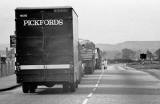
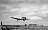
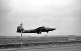
Photos Thank you to Colin for allowing me to reproduce the photograph above and three photos, all taken at Edinburgh Airport in the 1960s. Here are all three photos:
|
|||
|
1960s There has been discussion of the road passing Edinburgh Airport on this Recollections page. |