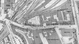
Morrison Street

1948 Map

1948 Ordnance Survey Map  -  Morrison Street

©  Ordnance Survey 1:1250 - NT 2473 SW & NT 2473 SE (published 1948)
Reproduced
by courtesy of the National Library of Scotland.
  Click here for further info, and for the NLS maps web site.

Google Image

Google Earth Image  -  Morrison Street, 1948

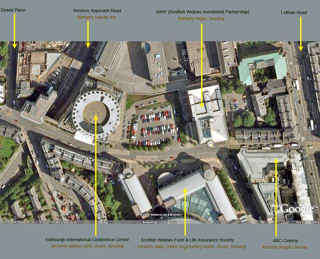
 ©  Google,  This page has been taken from the Google Earth web site


Morrison Street  -  New Buildings

Below are photos of some of the buildings that appear on the map and aerial photograph above.

Morrison Street - site of the former shops at 76 to 82 ©

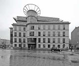
Looking NW across Morrison Street

Edinburgh International Conference Centre  (on the left)

Scottish Widows Investment Partnership  -  60 Morrison Street ©

Looking north across Morrison Street

SWIP:  60 Morrison Street

Scottish Widows Fund & Life Assurance Society -  69 Morrison Street ©

Looking west along Morrison Street

Scottish Widows:  69 Morrison Street

Scottish Widows Fund & Life Assurance Society -  69 Morrison Street ©

Looking SW from Semple Street/Morrison Street

Scottish Widows:  69 Morrison Street

Scottish Widows Fund & Life Assurance Society -  69 Morrison Street ©

Looking NW from Semple Street

Scottish Widows:  69 Morrison Street


Enlarge this 1948 map and Google Image

1948 Ordnance Survey Map  -  Morrison Street ©        Google Earth Image  -  Morrison Street, 1948 ©


Morrison Street  north side, early 1900s + 2009

Around Edinburgh

Recollections

Google Earth Views


__________________